Since early 2020, I’ve been tracking an effort at NOAA’s National Weather Service (NWS) and National Centers for Environmental Prediction (NCEP) to modernize and streamline their numerical weather prediction (NWP) systems. This is the Unified Forecast System (UFS) project.
A plethora of weather models
Prior to UFS, NOAA developed and ran a wide variety of specialized models. Advanced users could combine them for deep insights, but the overlaps often led to confusion, especially with public debates about which model performed better in specific regions, seasons, or for certain parameters.
For short-term forecasts (1–3 days) over the continental United States alone, NOAA offered (and still offers) several high-resolution options. Here’s what’s currently available in LuckGrib:
- HRRR — 3 km resolution, 18 hours, updated hourly
- HRRR 48 — 3 km resolution, 48 hours, updated every 6 hours
- NAM Conus — 3 km resolution, 2.5 days, updated every 6 hours
- RAP — 13 km resolution, 21 hours, updated hourly
- NBM Conus — 2.5 km resolution, 11 days, updated hourly
- NDFD Conus — 2.5 km resolution, updated hourly
Additional models (not in LuckGrib) include HIRESW, HREF, HWRF, HAFS, LAMP, and SREF. Many of these also have regional variants (Alaska, Hawaii, Puerto Rico, etc.).
For experts, this diversity adds value. For more casual users, like sailors or amateur enthusiasts, the choices can be overwhelming.
The UFS
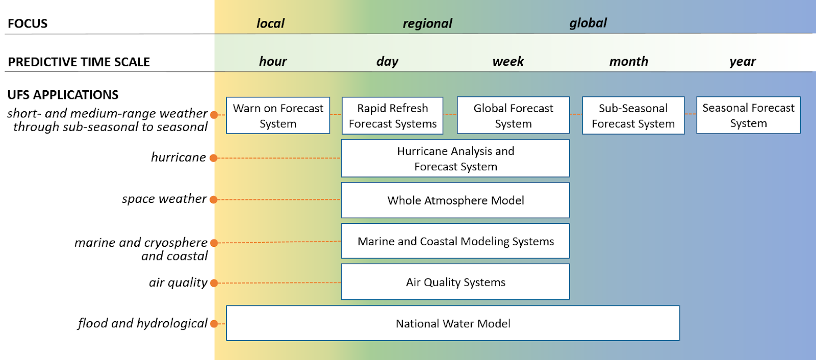 The UFS suite of models
The box labelled Rapid Refresh Forecast System is the most interesting in the short term, and is discussed further below.
The current operational GFS fills the medium-range role in UFS. The Climate Forecast System (CFS) appears to handle sub-seasonal to seasonal forecasts.
I expect that NOAA may continue offering some non-UFS models (e.g., the National Blend of Models (NBM) and specialized hurricane systems) alongside the core UFS suite.
If NOAA is able to successfully implement this UFS roadmap, it is going to make choosing a weather model much easier for the more casual users represented by the majority of LuckGrib customers. One high resolution short term forcast covering a large area surrounding North America, and one global weather model (alongside the others offered by, for example, ECMWF.)
RRFS
The UFS vision consolidates regional models into the Rapid Refresh Forecast System (RRFS), retiring HRRR, NAM, RAP, and others.
RRFS is effectively a superset of HRRR and NAM:
- ~3 km resolution (0.025° grid spacing)
- Hourly runs to 18 hours; every 6 hours (00Z, 06Z, 12Z, 18Z) to 84 hours (~3.5 days)
- Vastly expanded domain covering all of North America, including Alaska, Hawaii, the Caribbean, and parts of the Pacific
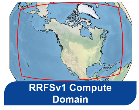 The RRFS domain as seen from space
In LuckGrib, the domain appears like this:
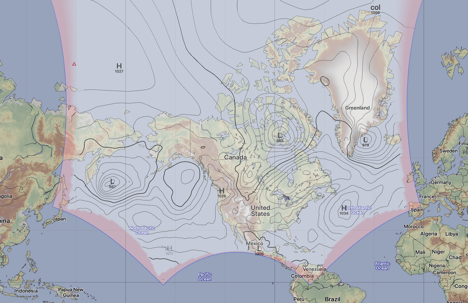 The RRFS domain in LuckGrib
Note that the pink areas in the image above represent areas of the RRFS grid which do not contain data. Also note that the hexagonal appearance of the grid is simply a Mercator projection artifact. The top of the grid passes close to the north pole, and the mercator projection kind of explodes as it goes further and further north.
RRFS will be invaluable for sailors. Compare its coverage to the HRRR and NAM Conus models:
 HRRR/NAM CONUS domain (blue box) inside RRFS
For sailors who sail the west coast, when traveling north to Alaska there were gaps between the HRRR / NAM coverage and the HRRR Alaska model. RRFS now provides a single, seamless model covering all passages along the west coast, up to Alaska, out to Hawaii, and South into Mexico and around the Baja Peninsula.
For the east coast, in the past, passages to Bermuda were out of range of HRRR but now are easily covered by RRFS. The Caribbean was covered with a bit of a mismash of different models, however RRFS covers the entire area including the entire Gulf.
It may have been nice if the domain favored some of the southern area a little more than the northern ones (hey, the team didn’t consult me haha). Sailors who are crossing into South America will need to fall back on the global models, or NBM Oceanic, for some areas south of around the middle of Mexico. Also, sailors crossing between Europe and North America have a coverage gap (filled in with DMI Harmonie, DWD Icon and Meteo Arpège).
RRFS version 2
RRFS version 1 has been frozen, and is currently (Feb/26) undergoing evaluation. The team is working on a version 2 of this new model. There has been some discussion that, for example, RRFS-v1 is not tracking hurricanes as well as HRRR. I don’t see this as a problem for sailors. Sailors don’t want to be anywhere near a hurricane, and won’t be using the forecast guidance in order to make a decision about moving a few hundred miles either way. During hurricane seasons, the safest place to be is far, far away. There is a plan in version 2 of RRFS to replace its dynamic core, to a different one which appears to behave better in these circumstances.
(Note that, while I have read that HRRR tracks hurricanes bettern than RRFS, its important to point out that HRRR could only track hurricanes once they were quite close to CONUS. RRFS is able to pickup hurricanes much further south and east.)
UFS and Artificial Intelligence
Note that the roadmap for UFS was introduced in around 2020. This was almost before AI, in its modern form, was available. Many people point to the ChatGPT moment, around mid December 2023, as being the moment that the new LLM based AI models started to become common knowledge. There had been work on LLM models before this point in time, but the ChatGPT moment may be the point which marks the start of AI, for the majority of people.
Since the UFS roadmap was produced, NOAA has released three AI-based systems outside the original plan:
It’s encouraging to see this adaptation, and I wonder how AI will reshape the UFS roadmap. Will RRFS be the last large traditional deterministic model that does not incorporate AI? The future looks fascinating.
Timing
As of the time this was written (Feb, 2026) the RRFS model is being advertised as becoming operational sometime in early 2026. As someone who has been watching the NOAA annoncements for some time, including the switch of GFS from its older spectral core to its new FV3 core, its clear that NOAA announces these major operational changes pretty far in advance. There has not yet been any announcement of the RRFS introduction date, so all current estimates should be taken with a grain of salt.
The plan with UFS and the RRFS, is that a number of models will be discontinued with the introduction of RRFS. Its not clear to me if there will be a period of time when all are available followed by the removal of HRRR, NAM, RAP etc or if that happens simultaneously.