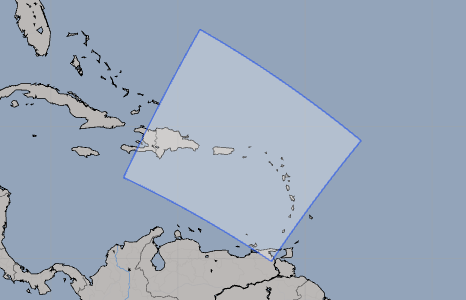
RAP Eastern Caribbean - Rapid Refresh
| Provider: | National Centers for Environmental Prediction, NOAA (USA) |
| Model scope: | Caribbean |
| Update frequency: | every hour |
| Resolution: | 0.146°, 8.8nm, 16.2km |
| Model duration: | 21 forecasts starting at 1 hr, ending at 21 hrs |
| Parameters: | pressure, wind, wind gust, rain, cloud, temperature, humidity, convection, simulated radar |
| GRIB model date: | Tue Feb 24 05:00:00 2026 UTC |
| Download date: | Tue Feb 24 06:12:20 2026 UTC |
| Download delay: | 1hr 12min |
Note: the Download delay is the amount of time required for the GRIB model to compute its forecast and then for the LuckGrib cluster to download the data and make it available. The LuckGrib delay is generally less than 10 minutes, the remainder of the delay is the model compute time.
Description
RAP is a weather model NOAA runs hourly, producing short term forecasts. There are several RAP domains.
As can be seen from the image of this models domain, this model covers the Eastern portion of the Caribbean. If this model is used with the main RAP model, most of the Caribbean waters will be covered with a model which is updated hourly.
The NAM Caribbean model will also be of interest, as it covers most of the region, at a slightly greater resolution, although it is only updated every 6 hours.
As RAP is a mesoscale model, it is able to model land and other features at a higher resolution than in a global model, leading to improved forecast accuracy.
For additional information, see: