NBM Conus (National Blend of Models)
| Provider: | National Weather Service, NOAA (USA) |
| Model scope: | North America |
| Update frequency: | every hour |
| Resolution: | 1.3nm, 2.5km |
| Model duration: | 53 forecasts starting at 0 hr, ending at 11 days |
| Parameters: | wind, wind gust, rain, cloud, temperature, humidity, ensemble standard deviation, other |
| GRIB model date: | Sun Jul 12 08:00:00 2026 UTC |
| Download date: | Sun Jul 12 09:08:49 2026 UTC |
| Download delay: | 1hr 08min |
Note: the Download delay is the amount of time required for the GRIB model to compute its forecast and then for the LuckGrib cluster to download the data and make it available. The LuckGrib delay is generally less than 10 minutes, the remainder of the delay is the model compute time.
About the National Blend of Models
The National Blend of Models (NBM) is an interesting suite of models, well worth considering as you evaluate weather systems.
The following is from an online description of the NBM:
The National Blend of Models (NBM) is a nationally consistent and skillful suite of calibrated forecast guidance based on a blend of both NWS and non-NWS numerical weather prediction model data and post-processed model guidance. The goal of the NBM is to create a highly accurate, skillful and consistent starting point for the gridded forecast. This new way to produce NDFD grids will be helpful providing forecasters with a suite of information to use for their forecasts. The NBM is considered an important part of the efforts to evolve NWS capabilities to achieve a Weather-Ready Nation.
As of May/2026, the NBM model is now at version 5.0. There is an announcement which details the changes in this latest release.
As of Oct/2020, the NBM model is at version 4.0.
The quoted text above mentiones that both NWS and non-NWS models are blended into the NBM.
The list of model inputs, for version 3.0 of NBM, is:
- NAM (North American Mesoscale Forecast System - 12km)
- NAMNest (NAM 3km high resolution nest)
- GFS (Global Forecast System)
- GEFS (Global Ensemble Forecast System)
- GDPS (CMC - Environment Canada Global Deterministic – PoP12/QPF06 only)
- GEPS (CMCE - Environment Canada Global Ensemble)
- EKDMOS (Ensemble Kernel Density Model Output Statistics)
- Gridded GFS MOS (GMOS or MOSGuide)
- HRRR (High Resolution Rapid Refresh), CONUS only
- RAP (Rapid Refresh). (Also RAP Alaska)
- Gridded LAMP (GLMP Localized Aviation MOS Product), CONUS only
- HiResWindow ARW NCEP (High-Resolution Window Forecast System (HIRESW))
- HiResWindow NMMB NCEP (High-Resolution Window Forecast System (HIRESW))
- SREF (Short Range Ensemble Forecast) CONUS, Alaska, Puerto Rico sectors
- NAVGEME (Navy FNMOC Global Ensemble)
The update to NBM, version 3.1, has added the following model inputs:
- ECMWFD (European Centre for Medium-Range Weather Forecasts, deterministic - 0.25 degree)(CONUS, OCONUS) (0000, 1200 UTC runs)
- ECMWFE (European Centre for Medium-Range Weather Forecasts, Ensemble - 1.0 degree)(CONUS, OCONUS) (0000, 1200 UTC runs)
- NAVGEMD (Navy FNMOC Global deterministic - 0.50 degree For most elements, 1.0 degree for significant wave heights)(CONUS, OCONUS, and Oceanic domain) (0000, 0600, 1200, 1800 UTC runs)
- GDPS (CMCD Environment Canada Global deterministic model (25km) for weather elements other than PoP12/QPF06)
- RDPS (Canadian Regional deterministic model - 10km) (CONUS and Alaska) (0000, 0600, 1200, 1800 UTC runs)
- REPS (Canadian Regional ensemble model - 15km) (CONUS) (0000 and 1200 UTC runs) (Precipitation products only)
- HRRR Alaska (High Resolution Rapid Refresh - 3km) (a). 1-18 hours (0300, 0900, 1500, 2100 UTC runs) (b). 1-36 hours (0000, 0600, 1200, 1800 UTC runs)
- HiResWindow ARW Mem2 (3-km High-Resolution Window Forecast System (configured like NSSL WRF) (CONUS and OCONUS)
- WW3 (0.5 degree WaveWatchIII global deterministic model)
- WW3 (0.5 degree WaveWatchIII global ensemble model)
- WW3 (0.16 and 0.06 degree WaveWatchIII high resolution regional models) (CONUS and OCONUS)
- GLW (2.5km Great Lakes Wave model)
The v3.2 update to NBM has added the following model inputs:
- ACCESS-G (The Australian global model)
- GFS-FV3 visibility
- additional improvements for other weather elements (temperature, rain, …)
The v4.0 update to NBM has added the following model inputs:
- GFS-MOS (0000-, 0600-, 1200-, and 1800-UTC cycles)
- Deterministic ECMWF-MOS (0000- and 1200-UTC cycles)
- Ensemble ECMWF-MOS (0000- and 1200-UTC cycles)
- EKDMOS (0600- and 1800-UTC cycles)
- NAM-MOS (0000- and 1200-UTC cycles)
- LAMP (hourly)
The blending process
The word blend in NBM represents the key feature of this model. A wide variety of models are blended into the NBM final result. This blending process has been shown to improve the skill level present in the individual models.
Cliff Mass, an Atmospheric Science professor at the University of Washington, has published a presentation describing the blending process, referred to as MOS. The presentation is an interesting read, if you want to understand some of the techniques that may be present in the NBM blending process.
The blend in the NBM is different from an ensemble model in two major ways.
first, the blending in the NBM does not use simple averaging, and Prof. Mass’s paper talkes about how this may work, in some detail. The blending in NBM is much more sophisticated than a simple average, and it is able to improve the skill of the result as well as retain detail in the data.
secondly, the input models to the blend are from a wide variety of sources, both from NOAA and from outside of NOAA. For example, models from both Canada and the US Navy are included as elements of the blend. Both high resolution regional models and global models are considered. In a way, the NBM is a meta-ensemble, an advanced blending of other ensemble (and non-ensemble) models
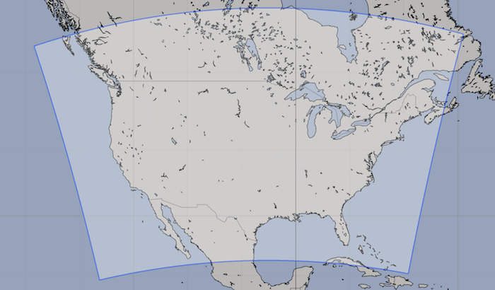
NBM Conus
A brief comparison of the NBM Conus domain to the NDFD Conus domain is useful. Where the NDFD Conus data is restricted only to the USA, the NBM data covers the entire grid, including the portions of Canada and Mexico that the NDFD data omits.
The NBM Conus domain is also slightly larger, extending further west and north compared to the NDFD domain.
Additional Information
For additional information, see: